Official Answers by Chaosium
![]()
- Introduction
- Sartar
- Far Point
- Tarsh
- Wintertop & Old Tarsh
- Grazelands
- The Wilds
- Bestiary of The Wilds
- Master Map
![]()
- RuneQuest: Roleplaying in Glorantha Quickstart – Q&A
- RuneQuest: Roleplaying in Glorantha – Q&A by Chapter
- RuneQuest Gamemaster Screen Pack – Q&A
- RuneQuest Glorantha Bestiary – Q&A
- The Red Book of Magic – Q&A
- The Smoking Ruin & Other Stories – Q&A
- Pegasus Plateau & Other Stories – Q&A
- RuneQuest Starter Set – Q&A by Book
- Weapons & Equipment – Q&A
- The Prosopaedia – Q&A
- The Lightbringers – Q&A
- Earth Goddesses – Q&A
- Mythology – Q&A
- The Lunar Way – Q&A
- The Glorantha Sourcebook – Q&A
- Dragon Pass – Q&A
- The Gods of Fire and Sky – Q&A
![]()
Introduction
The Political Development of Dragon Pass 1500-1600 map (page 19)
Roadend location
The location of Roadend is different from the Master Map
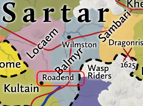
Always use the Dragon Pass Master Map for more accurate locations. The right map is correct, the left is an error.
![]()
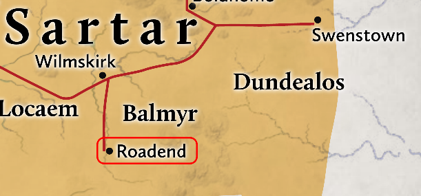
Smithstone location
The location of Smithstone is different from the Dragon Pass 1625 Map (page 23)
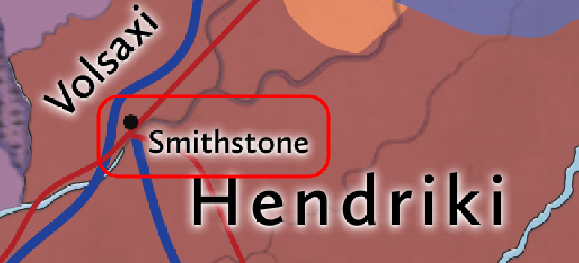
The 1625 Map map is correct. There is currently no version of this area in the format of the Dragon Pass Master map. The best current resource is the map in the Hendrikiland or “South Sartar” article (map below), It’s part of the same trace of Greg’s master map that the Dragon Pass Master map is based on, just a bit further south. You can see where Smithstone is on there.
![]()
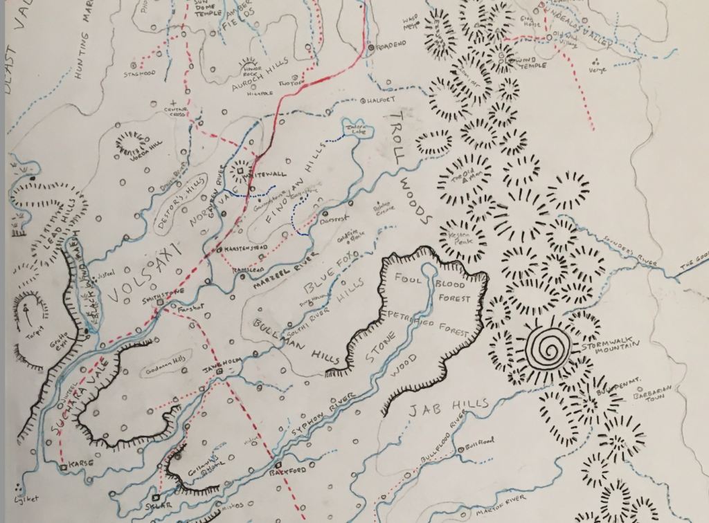
Karse location
The location of Karse is different from the Dragon Pass 1625 Map (page 23)
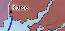
The 1625 Map map is correct per the map (above) in the Hendrikiland or “South Sartar” article (as above).
![]()
Dragon Pass 1625 Map (page 23)
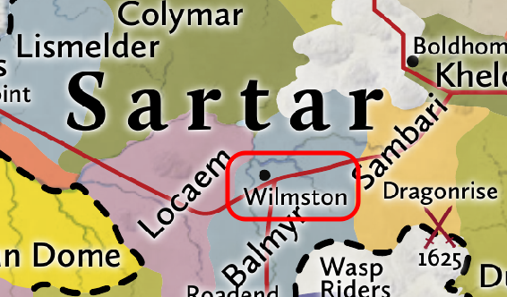
Wilmskirk Clarification
Wilmston, Wilmskirk and Wilmschurch city.
Note that Wilmston is not incorrect as Greg did call it Wilmston in the 1992 playtest materials for Glorantha the Game (unpublished). The same document also calls it Wilmschurch city:
![]()
Palace of Black Glass Correction
Delete – Palace of Black Glass on the Shadow Plateau (destroyed in 1316)
![]()
Black Horse County Typo
Black Horse Country
Sartar
People Everyone Knows
typos
Kallyr Starbrow (page 41)
She is a great-great-granddaughter of Prince Saronil.
![]()
Vanstana Ingini (page 44)
‘Princess’ Vanstana is a Goldentongue Priestess,
![]()
Ingini Surname
On the Dragon Pass Master Map as well listed in the Points of Interest there is a village Ingan only. So could this be a typo?
No
And if so, shouldn’t be the name Vanstana Ingani?
No. It’s a surname and likely altered by gendered spelling.
![]()
Sartarite Adventurers Box (page 43)
Correction
In 1625, when the Lunars invested heavily in their Temple of the Reaching Moon in Sartar,
![]()
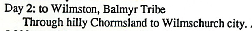
Boranni River (pages 49, 50 and 57)
Boranni vs. Boranini
In:
- Boranni River (page 49)
- Clay Man (village) (page 50)
- Frithan (village) (page 57)
On the Dragon Pass Master Map (as well as on the Colymar Tribes map from the Gamemaster Screen Pack and in the RuneQuest Starter Set) the name of the river is Boranini
Boranni River is correct. On Greg’s master map the lower part is called the Arfritha River. Boranini is an ancient typo (with both variants in the Sartar companion).
Here it is on one of his traces of his master map:
![]()
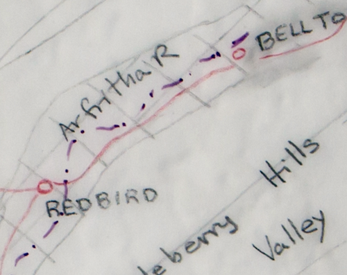
Broke-Rock Hills (page 49)
Location
Where are the Broke-Rock Hills in relation to the Sambarri Pass?
See the map below. The Sambarri Pass (Red) is now a valley where Orlanth used big Weighty to squash the mountain god who lived there. The Broke-Rock Hills (Blue) are what the dwarfs cut through into the valley. I suspect the actual Sambarri Pass was over what is now the Broke-Rock Hills. But the whole valley is still called the Sambarri Pass
![]()
Dragon Creek
Duplicate Text
The entry for Dragon Creek (using the same text) appears in the Sartar chapter as well as in the Far Point chapter.
Is this intentional or should this appear in the Far Point chapter only?
This correct as it forms the border between the Far Point and Sartar.
![]()
Geo’s Ridge Inn (page 57)
Thorgeir Ridge / Culbrea Mountains
Thorgeir Ridge is not mentioned anywhere else (neither in the text nor on the Dragon Pass Master Map nor on the Quivin Mountains map on page 68), but I guess this means the ridge which includes (Thorgeir’s) Knee and Shoulder. But on the Quivin Mountains map this ridge is named Culbrea Mountains. Is that correct?
Yes. Two names for the same thing. One by mythology one by common view.
![]()
Kagradus Peak / Hordos
Kagradus Peak is not located along the King’s Road. In fact the peak on the other side of the King’s Road, where Geo’s Ridge Inn is located, has no name, as far as I know, neither on the Dragon Pass Master Map nor on the Quivin Mountains map. So do we know the correct name of this peak?
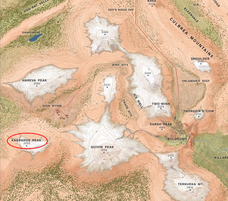
Yes. Hordos (2480) from one of Greg’s master maps.
On the Colymar Tribe Map in the Gamemaster Screen Pack the name of this mountain seems to be Hordos Mountain. So this is the correct name?
Yes.
Note that Greg didn’t name all the peaks and those that he did have his usual inconsistent spelling, and depending on the map – different names (and some notes):
- Kagradus (first king of the Colymar)/ Korgradus
- Hareva Peak (Kagradus’s wife)/ Eagles Mount
- Hordos – Colymar’s father
![]()
Old Elf Ruin (ruin) (page 66)
Theyalan Age
I have never seen the term ‘Theyalan Age’ before. Also couldn’t find it in the Well of Daliath.
So is there a description anywhere, or is there an equivalent term?
Theyalan Age is a synonym for Dawn Age. It appears in a few places in Greg’s notes and as such has been used in this entry.
Typical Wasp Rider (page 77)
Hit Locations Typo
| Location | D20 | Armor/HP |
|---|---|---|
| Head | 19-20 | 4/4 |
Far Point
Dragon Creek
Duplicate Text
The entry for Dragon Creek (using the same text) appears in the Sartar chapter as well as in the Far Point chapter.
Is this intentional or should this appear in the Far Point chapter only?
This correct as it forms the border between the Far Point and Sartar.
![]()
Lizardwood Flats and Lizardwood Wilds (page 92)
These two entries have (nearly) the same text. Only difference is the description of where the POI is located. Is this intentional?
Yes
or is this an editing issue?
No
See the map on page 87 of the Pegasus Plateau. In this closeup you can see the distinction.
Tarsh
Porters, Climbers and Haulers
In the Wintertop & Old Tarsh section several times ‘porters, climbers and haulers’ are mentioned, and it seems these people are used/needed, when going into the ḿountains. So I have a quite clear idea, what a ‘porter’ or a ‘climber’ may be, but what is a ‘hauler’ (especially in this context)?
In this context, a hauler is someone who hauls – in this case uses a cart to transport goods. As Chaosium uses American English, always start with the Merriam-Webster Dictionary for definitions. In British English the archaic word carter could be used.
Note that there are a myriad of speculative possibilities, given that the word isn’t used this way anymore. For example it could mean hauling goods up ropes or in a hand cart or beast drawn cart. None of these are specifically covered in the Mountaineer occupation,except possibly high STR.
![]()
New Occupations – Athlete & Gladiator
Bold skills used to determine annual income
- Athlete (page 99): Jump +30%
- Gladiator (page 99): 1H Weapon (pick type) +30% or Shield (medium or small) +30%
![]()
Missing map locations
Belensfield (village)
Unlabelled village in the Belen Hills, the battle marker is also missing.
Dantafol (village)
Unknown, locate it were needed (personally I’d stick it in Shakeland. It’s important in 1645 as the site of the Battle of Dantafol (Maybe hex 1917 on the Dragon Pass board game map).
Greenbow (village)
Southern Barnteri Hills – unlabelled
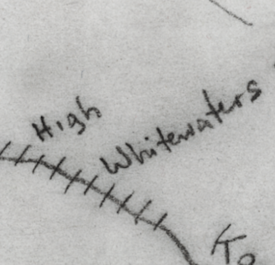
High Whitewaters
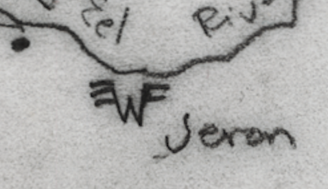
Jeron (ruins)
Leftover (village)
First village south on the military road from Goldedge to Bagnot – unlabelled
Sowford (village)
AKA Boarford on the map
Three Ribbons & Five Chambers (village)
East of the Barnteri Hills, south of the group of trees – unlabelled (See also ToTRM #6, Three Ribbons & Five Chambers).
![]()
Stones of the Dancing Girls
This entry is listed in the Tarsh chapter, but on the Master Map the Stones of the Dancing Girls are clearly shown in the Grazelands area. So is this an editing error?
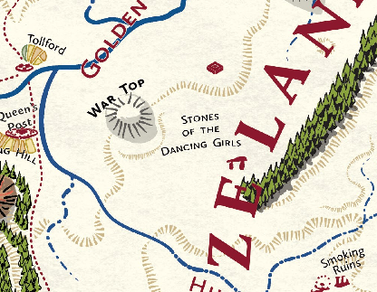
Yes, they are in the Grazelands, see also Pegasus Plateau 9-10 and 13.
![]()
Talsderen Vale
‘This fertile valley was once the homeland of the Barteri Tribe.’
Given that we have the Barnteri Hills nearby, and that the description of these hills (p. 101) contains a description of its inhabitants quite similar to the description of the Talsderen Vale, could it be, that this in fact should be the Barnteri Tribe?
No. Barteri is correct (see also map on 15)
Wintertop & Old Tarsh
New Occupation – Mountaineer
Bold skills used to determine annual income
- Mountaineer (page 125): Climb +30% or Survival +20%
Grazelands
Jandetin the Avenger (page 131)
Typo
Jandetin -> Jadetin per Glorantha Sourcebook (Second Edition, page 43) and King of Sartar (Second Edition, page194)
![]()
New Occupation – Laborer (page 138)
Bold skills used to determine annual income
- Laborer (page 138): Craft (specific craft) +10%, Herd +10%, or Listen +20%
![]()
The Melibkron (page 141)
Hit Locations Typo
| Location | D20 | Armor/HP |
|---|---|---|
| Abdomen | 10 | 2/7 |
| Torso | 11-12 | 2/8 |
The Wilds
Dragon Newt Road System map (page 155)
Typos
- Change Dragon Newt Road System to Dragonewt Road System
- Change Dragon Newt City to Dragonewt City
- Change Ghost-Around to Ghosts Around
![]()
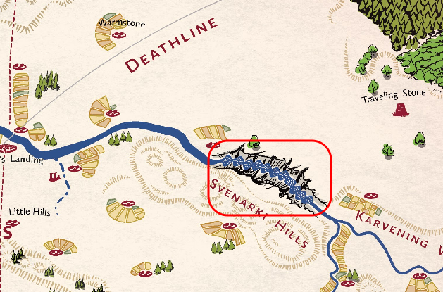
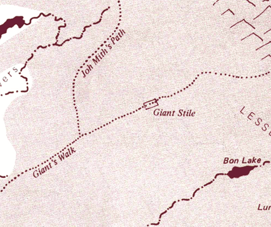
Giant’s Stile (page 158)
This place is not marked on the Dragon Pass Master Map, but my guess would be, that it is located, where the Giant’s Walk crosses the Ridge of Thieves. Is this assumption correct?
Yes, as on the Trollpak Dagori Inkarth map:
![]()
Grub Farm (page 158)
According to the RQ2 Classic Trollpak reprint (page 151) and the RQ3 supplement Into the Troll Realms (pages 28/29) the Grub Farm should be in the eastern part of the Vale of Flowers north of the Trade Path, which itself is located north of the Zanthali Hills.
Note that Classic Trollpak locates it Near the northeast corner of the Vale of Flowers, […] The farm nestles on the southern edge of a valley in the Lesser Ridges. This valley is about 3 by 1.5 kilometers, running east and west.
Which not only doesn’t correlate with the map provided, but is off that map (near Bon Lake). It is also incorrect on the Dagori Lnkath map.
The entry itself has no description about its location, and on the Dragon Pass Master Map the location of the Zanthali Hills and the Trade Path match the description respectively the maps provided in above publications. But Grub Farm is now south of the Trade Path! Is this change of the location intentionell?
Yes. It’s been moved into the Zanthali Hills as it’s the territory of the Indigo Mountains Troll Tribe.
See also the map:
It can easily be relocated should a GM need to do so,
![]()
Koffer Hills (page 160)
Origin of the name
Where does this name come from? Being a native German I’m a bit confused about the name, as Koffer is a suitcase in German, and my dictionary gives me no English -> German translation for this word. Is this just a name without any meaning?
Confusion understood. It’s on Greg’s original map. I suspect it’s someone’s surname. However see here, maybe it’s just an old word he found for farmer, idiot or village.
![]()
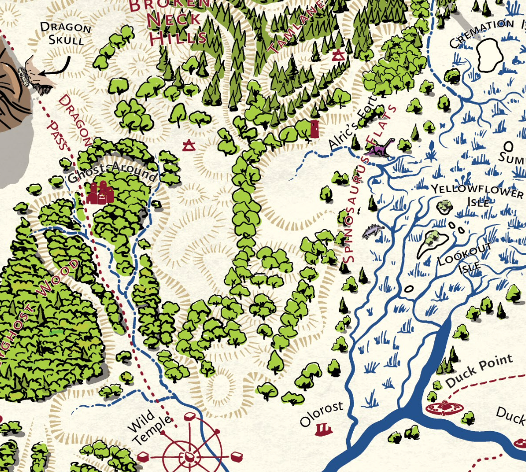
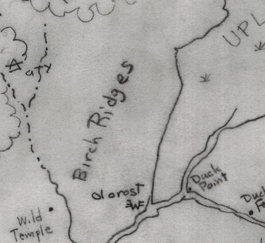
Spinosaurus Flats (page 167)
Location of the Birch Ridges
“Dinosaurs are common here in the fertile bottomland between the Birch Ridges and the Upland Marsh.”
What are the Birch Ridges? Not marked on the Dragon Pass Master Map.
See the Master map and Greg’s master map below
![]()
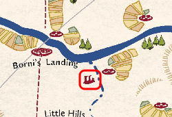
Traveling Stone (page 168)
Typo
is usually found southwest of the Greatway peaks
Exact Location
Why usually found? Is this stone really travelling?
It does wander a bit as it’s a magical altar.
![]()
Varna’s Path (page 169)
Descriptive text
This entry has the nearly same text as the entry for “Twentytwo Turns” on page 168.
Yes see Classic Snakepipe Hollow, page 3 and the tower marker is missing is missing on the Master Map
Is there really a tower? Just asking, because Donkeys Only also has no tower.
Yes there is a tower
![]()
Wyrms High Pass (page 170)
Wyrms High Pass and High Wyrm Pass
On the Dragon Pass Master Map this pass is named “High Wyrm Pass, so which is the correct name?
Given that this pass was called Wyrms High Pass in Griffin Mountain and the same name is used in the Guide to Glorantha, I guess the naming on the Dragon Pass Master Map is wrong.
Both are correct. Greg was not consistent in naming., and also applies in the real world.
![]()
Yinkin Hill (page 170)
Yinkin Hill and Yinkin Hills
On the Dragon Pass Master Map the name is “Yinkin Hills”. Which is the correct name?
Yinkin Hill (there is only one) is correct, the rest are Ten Ridges.
Bestiary of The Wilds
Bird Women
Stat Block Typo
Sorcery: Magic Point Enhancement 35% -> Magic Point Enchantment per RQG, page 396.
![]()
Runes and Sorcery Runes
In the spell list for Sorcery it says: “Knows the Fertility and Spirit Runes and the Command technique.”
But under Runes the Spirit Rune is not listed. What is value of the Spirit Rune for a Bird Woman?
Bird Women do not have the Spirit Form Rune. Sorcerous Runic knowledges are not the same as Runic affinities.
See Runes, (RQG 381): A sorcerer’s understanding of a Rune is not based on their affinity with that Rune, nor is it a skill. (RQG 383).
![]()
The Hydra of Dragon Pass (page 175)
CON
The hydra does not have a CON characteristic. I suggest a value of 450.
It has CON 354
Note that in RQ3 it had CON 610 (Elder Secrets of Glorantha, page 30), and that hit point calculations were different in that edition (Total hit points were the average of SIZ plus CON), from RQ2 and RQG (CON + SIZ Bonus + POW Bonus).
CON Calculation:
- Hit points = CON + SIZ Bonus + POW Bonus
- 530 = CON + (SIZ 450-12=438/4 = 110) + (POW 280-16 = 264/4 = 66)
- 530 = CON + SIZ Bonus 110 + POW Bonus 66 (total of 176)
- 530-176 = CON 354
Master Map
Dragonspine Clarification
Dragonspine is used with several different terms:
Dragonspine Hills – p. 140 as well as on the Political Development Maps on p. 15 and p. 23
Dragonspine Ridge – pp. 120, 134
Dragonspine Mountains – pp. 27, 168
Dragonspine Mountain – p. 139 (not in the Index)
Dragonspine Range – p. 136 (not in the Index)
First – Look at the panorama at the bottom of page 6, you will see the complete structure from the Quivin Hills. As you get nearer the overall structure disappears from the viewers perspective.
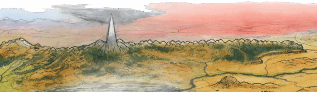
So – It’s all the same thing, the range is a ridge made up of mountains and hills. Specific combinations refer to specific parts. For example the hills lead up to the mountains that form an irregular ridge (that is the spine of a dragon). There are specific mountains named.
The Dragon Pass Master Map knows Dragonspine Mountains (south-west of Spirit Mountain) and Dragonspine Ridge (north of Kero Fin, between the West Bush and East Bush Ranges) only. These could be two parts of the same Mountain range with a hilly low in-between. In this case the Dragonspine Ridge would be part of the Dragonspine Mountains. Or these could be two completely different geological areas. Or is Dragonspine Ridge just a synonym for Dragonspine Mountains? Which is the canonical view?
See above
Dragonspine Hills seems to be a misnomer. Hills are something completely different than mountains. I was not able to find this denomination anywhere else, and The Guide to Glorantha knows Dragonspine Mountains and Dragonspine Range only. So I guess, Dragonspine Hills should be replaced with Dragonspine Mountains. Is this correct?
See above
Dragonspine Mountain is used in the description of the Seven Bulls Trail only, with a reference to the Belastran Pass. On the Dragon Pass Master Map there is no Dragonspine Mountain near the Belastran Pass (or the Seven Bulls trail), but Belastran Pass crosses the Dragonspine Mountains obviously. My guess is, that this is a typo and should be fixed. Is this assumption correct
Typo – should be plural – Dragonspine Mountains.
Dragonspine Range is used once only as an area specification for the Lookout Mountain. On the Dragon Pass Master Map the Lookout Mountain is clearly part of the Dragonspine Mountains. In the Guide to Glorantha Dragonspine Range seems to be used as a synonym for Dragonspine Mountains, so it seems to be just that: a synonym. Is this correct?
Yes. See above
Additionally the unattached term Dragonspine is used on pp. 120, 121, 125, 135, 161, but these appearances of the term are listed in the Index under Dragonspine Mountains, except for p. 135. So Dragonspine is a synonym for Dragonspine Mountains obviously. Index should be fixed.
See above.
Also note: on p. 134 the Dinosaur Hill is marked and described as part of the Dragonspine Ridge. But on the Dragon Pass Master Map (as well as on the map above this description) it is clearly part of the Dragonspine Mountains.
Same thing. Note that dinosaur hill is not sharply pointed. It’s a broken spine, so appears to be hill-like.
Directly afterward is an entry for the Dragonspine Ridge. But the map above this entry displays the Dragonspine Mountains only, which has no entry, neither in the Wilds chapter nor anywhere else. Needs to be fixed? (Dragonspine Ridge is visible on the Master Map excerpt displayed in the Wintertop & Old Tarsh chapter.)
See above.
On page 6 I can see, that the Dragonspine ends on the right side in something, which in fact looks like the head of a Dragon. What is it?
It is the head of a dragon.
In the Dragon Pass Master Map this area (north of Miskander’s Tower at the end of the Dragonspine Ridge) is called Dinosaur Skull Hill. But even here it looks more like a Dragon Skull (alone the size hints into that direction). In fact, as the Dragonspine is the backbone of Sh’harkazeel, my immediate guess would be, that this could be the skull of Sh’harkazeel. But Dinosaur Skull Hill not mentioned anywhere else in Lands of RuneQuest: Dragon Pass, so the question is: How does it come, that this area is called Dinosaur Skull Hill and not Dragon Skull Hill?
It comes from Greg’s original map. He labeled it Dinosaur Skull Hill. The Dragonspine north of Kero Fin is also labeled Dinosaur Ridge, where the southern section is Dragonspine Hills. There are dinosaurs in the area, there’s even a green one close to Dinosaur Skull Hill on the map. See also Dinosaur Ridge. The whole area is associated with dinosaurs, rather than the once great dragon.
![]()
Twenty-two Turns Tower Icon
Correction
This should be an open air temple icon ![]() marking the Storm Bull temple per New Hills (page 92) not a tower icon
marking the Storm Bull temple per New Hills (page 92) not a tower icon ![]() .
.
Related Pages
Page Last updated: 2025-08-20 16:18:08