Skip to content
The Well of Daliath
Menu
Menu

Royal Roads of Dragon Pass

Posted on September 1, 2013

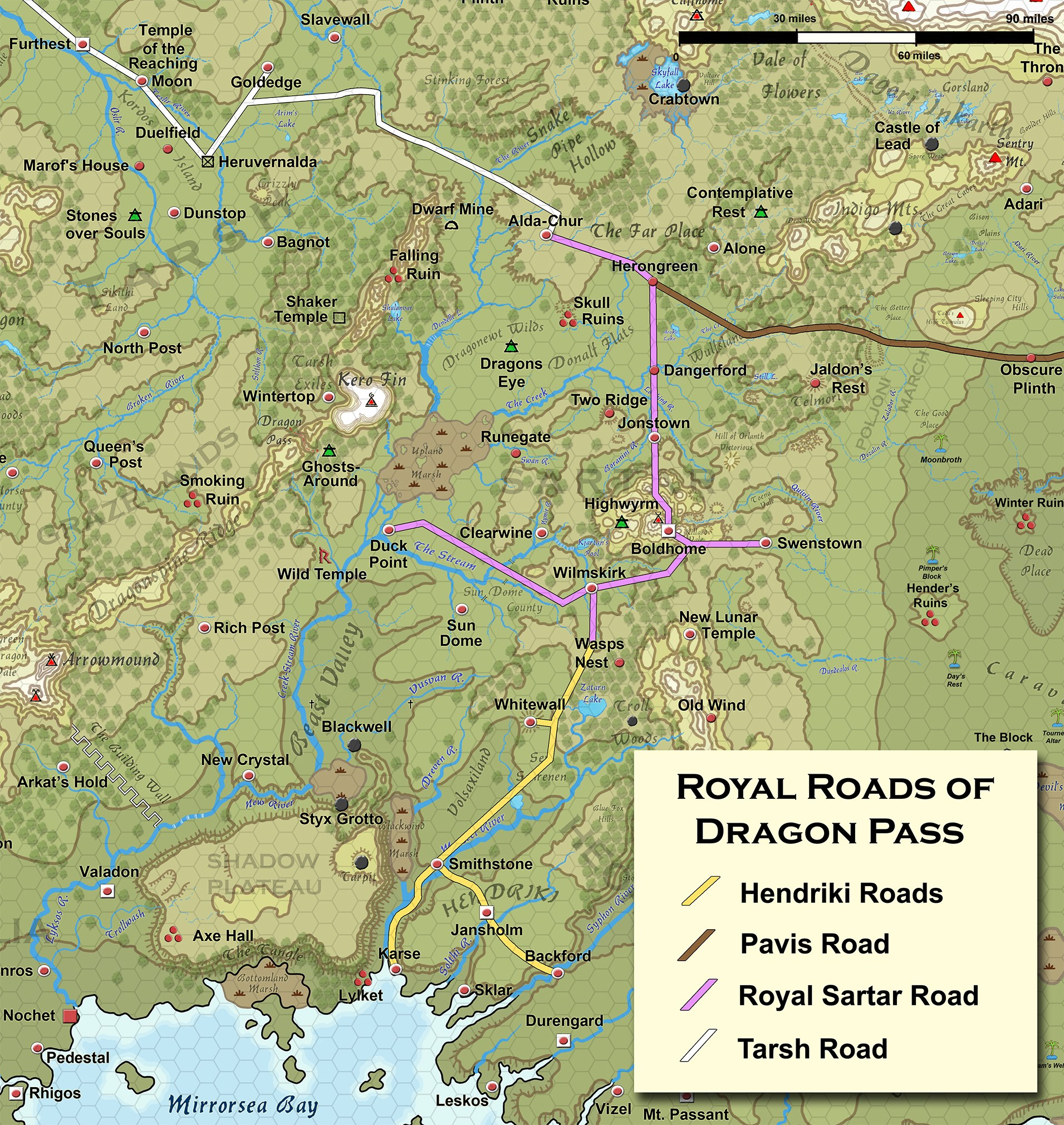
Here’s a nice little map showing the royal road network of Dragon Pass.

These are Greg’s maps and Greg’s distances (really, I have all of Greg’s master maps). It is entirely possible that when Greg looked quickly at a map he gave an overly large distance in an email response. I know I have done that at on more than one occasion!

I count 21 hexes from the southern border of Sartar  to Snakepipe Hollow (I count hexes – that’s why I prefer hexes). On the original White Bear & Red Moon map, I count 21 hexes (same 5 mile per hex scale) between the same points. 

That’s the scale of Sartar – about 105 miles from north to south, and about the same from east to west. That’s about 70% the size of modern Switzerland, and larger than the modern province of Lombardy (which managed to play a pretty big role in history). It is almost half-again as big as the ancient kingdom of Ulster which makes it as big a kingdom as any the High Kings of Ireland every directly ruled.

Those seriously are the distances that have always been on Greg’s master maps. Just to give an idea of their age, the overall shape and size of Fronela was established in the late 60s, Dragon Pass was set in 1975. Greg’s master map of Dragon Pass (which used to hang up at the Chaosium office and is now here in Fortress Berlin) dates to the late 70s (with many revisions hand-drawn by Greg over the following decades). The master map of Central Genertela and the West dates to the early 80s, as do Greg’s detailed maps of the West. All of these maps are remarkable consistent on internal scale once you crack the code.

What WAS inconsistent was the maps done by other artists. The Lunar Empire map that Issaries did was wildly off on scale, the various maps in the Orange box were also weirdly off from the master maps (they actually worked off a far less detailed map rather than work off the detailed master maps). But these dimensions really are what Greg has had up on his wall for decades.

In the period 1614-1620 would the Lunars have added a roadway to their new temple to improve transport? Unlikely to be anything more than a dirt wagon road.

Well it is the scale we’ve always had (seriously, these maps have been around a LONG time).  At 3,125 miles, the northern continent of Genertela is slightly wider than the continental United States, which given that much of the mythic geography of Genertela is taken from the United States (Rockies, Mount Rainier, Mississippi River, Devil’s Tower, the San Francisco Bay area, the Great Basin, etc.) seems entire appropriate.


Originally posted on G+. Tapatalk Archive.

Jeff Richard

Next
Previous
G+ post, Guide to Glorantha (preview), Map, Royal Roads, Tapatalk post

Sections

  • Search Tips
  • Current RuneQuest Glorantha Publications
  • RuneQuest Glorantha Corrections and Q&A
  • Catalogue
  • References for Glorantha
    • Gloranthan Canon
  • Gloranthan Documents
  • RPG Systems & Versions
  • Gallery
  • About This Site
  • Get involved!

Latest Posts

  • The Grasslands of Prax

    Something to keep in mind about Prax. The grasslands of …
  • Praxian Kinship Groups

    Praxian tribes are divided into smaller kinship groups or clans, …
  • Lunar Resettlement of Tarsh after 1460 ST

    After 1460, large sections of Peloria (especially east of the …
  • The Spread of the Lunar Way

    In the Lunar Provinces, about 26% of the total population …
  • Gods of Fire and Sky and the Lunar Way

    The Gods of Fire and Sky co-exist alongside the Lunar …
  • How Much Land is a Hide?

    So in RQ, a “hide” is a unit of accounting …
  • Agricultural Data for RuneQuest

    Back in the late 70s and early 80s, Greg‘s only …
  • Farming in Dara Happa

    In anticipation of the Fire/Sky Book, here’s a few notes …
  • Farming in the Big Rubble

    There are some 1600 humans in the Big Rubble, with …

Links

  • Chaosium
  • Chaosium’s RuneQuest RPG Wiki
  • Glorantha on BRP Central
  • RuneQuest on BRP Central
  • RuneQuest on Discord
  • Prince of Sartar Webcomic
  • Glorantha G+ Archives on Tapatalk
  • Search mailing list archive

Latest from BRP Central

  • Thoughts on running an Animal Nomad/Praxian game
  • Fillable excel RQG character sheets?
  • Where is there a list of temples in Dragon Pass?
  • New on the Jonstown Compendium: Many Suns
  • control entity spirit spell question
  • Subcults vs Associated Cults
  • Gorgorma and Dendara's Chess Game
  • Merged deities
  • Elf plant ships and dwarf stone ships
  • Do Dwarves have souls?

Popular Tags

Boldhome (large city) Chaosium Colymar (Sartar tribe) Contents Cult demographics Cults of Runequest (preview) Ernalda Esrolia (homeland) FRA Furthest (large city) G+ post Gods Wall Greg Stafford Guide to Glorantha (preview) Humakt Jar-eel Lunar Empire Lunar Pantheon Magazine Malkioni pantheon Map Michael O’Brien Mongoose MRQ1 New Pavis (small city) Old Glorantha Q&A Orlanth Orlanthi pantheon Photo reference Population demographics Prax (homeland) RQ3 RQG Sandy Petersen Sartar (homeland) Spirit Cult Star Subcult Tapatalk post Tarsh (homeland & Lunar province) Troll Pantheon Yelm Yelmalio Yelm Pantheon Youtube

Recently added or updated

  • Spirit Magic by Cult and Associate Cult

  • ISS1102 Glorantha: Introduction to the Hero Wars (2000)

  • Dragon Pass – A brief outline (2013)

  • Some Fronelan Population And Cultural Details

  • Notes on Fronela III

  • Notes on Fronela II

  • Notes on Fronela I

  • Hon-eel Temples and Shrine

  • Seven Mothers Temples and Shrines

  • Ernalda Temples and Shrines

  • Barntar Temples and Shrines

  • Babeester Gor Temple and Shrines

  • Voria Shrines

  • Ty Kora Tek Temples and Shrines

  • Asrelia Temples and Shrines

  • Maran Gor Temple, Shrines and Site

  • Odayla Shrines

  • Humakt Temples, Shrines and Sites

  • Orlanth Rex Temples, Shrines and Sites

  • Hippoi Shrines

©2025 The Well of Daliath | Design: Newspaperly WordPress Theme