Skip to content
The Well of Daliath
Menu
Menu

Sartar Map Update I

Posted on October 1, 2020
Sartar map by Matt Ryan

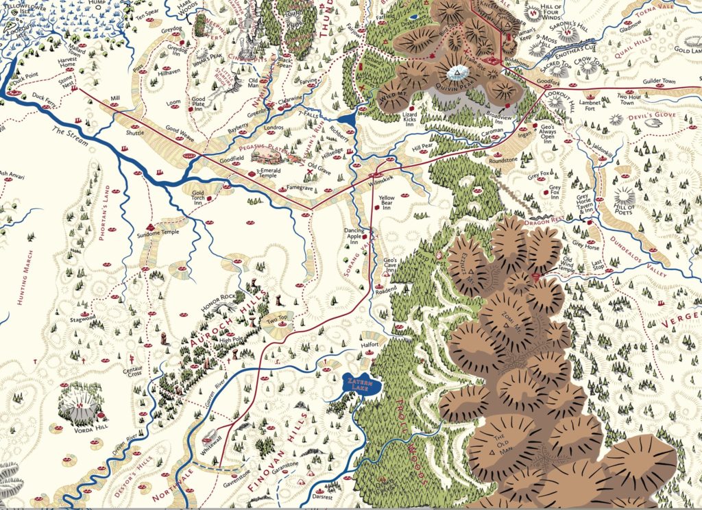
BTW, this is only about 20% of the map we are putting together right now.

Not every village is going to get named. The intent is to give folk freedom to have their own villages, and also to not tie author’s names. The named villages have enough existence to warrant it, and enough details to support a text description.

This map really helps to explain and visualise Sartar. Well the whole map together does, this is just South Sartar and Volsaxiland. But it also has tribal boundary overlays. And it contains ALL the information on Greg’s master map, plus much more.

And these inns are extremely important – they support the caravan trade which is the lifeblood of the kingdom.

The Broadview Inn caters to foreigners, travellers, and even has an Issaries shrine. Not to mention entertainment and better booze.

And also has an amazing view of south Sartar. I mean look at its position. It is like an Alpine hikers hut.

The inns of Sartar, as an aside, are caravanserai. Like the Selim Pass Caravanserai in Armenia

But for my money, the best inn in Sartar is Geo’s Ridge Inn.

How does the Sartar road going through the Quivin Mountains manage to be so straight? It is cut right into the mountains. The roads of Sartar are better engineered than Roman Roads, and have always been described as such.

This is part of the reason that the description of Sartar presented in the Hero Wars material was so problematic.

HW/HQ described them like that, but Thunder Rebels then completely ignored the roads, their importance, and the importance of trade and commerce. And cities. And barely acknowledged the tribes. Now a big part of that was the looming influence of KoDP, but KoDP was set three hundred years before. KoDP cast a huge shadow over what everyone was doing at the time. It couldn’t help but do so. Heck, it was the source of most of the better artwork during the period.

One of my favorite little features on that map is the little village right up against the Crossline near the Zatern Lake. Now I don’t know if that village has been around since the beginning of the Third Age (I actually kind of doubt it) but if it has, imagine how weird that would have been. You can go to the edge of the fields, but not beyond. Or you will DIE. Kind of like living in Berlin in the 1970s…

More than any map since the map showing the Eiritha Hills as a giant herd beast, this map really shows the fantastic and mythic geography of Glorantha.

Jeff Richard

Next
Previous
Map, Matt Ryan, Sartar (homeland)

Sections

  • Search Tips
  • Current RuneQuest Glorantha Publications
  • RuneQuest Glorantha Corrections and Q&A
  • Catalogue
  • References for Glorantha
    • Gloranthan Canon
  • Gloranthan Documents
  • RPG Systems & Versions
  • Gallery
  • About This Site
  • Get involved!

Latest Posts

  • The Grasslands of Prax

    Something to keep in mind about Prax. The grasslands of …
  • Praxian Kinship Groups

    Praxian tribes are divided into smaller kinship groups or clans, …
  • Lunar Resettlement of Tarsh after 1460 ST

    After 1460, large sections of Peloria (especially east of the …
  • The Spread of the Lunar Way

    In the Lunar Provinces, about 26% of the total population …
  • Gods of Fire and Sky and the Lunar Way

    The Gods of Fire and Sky co-exist alongside the Lunar …
  • How Much Land is a Hide?

    So in RQ, a “hide” is a unit of accounting …
  • Agricultural Data for RuneQuest

    Back in the late 70s and early 80s, Greg‘s only …
  • Farming in Dara Happa

    In anticipation of the Fire/Sky Book, here’s a few notes …
  • Farming in the Big Rubble

    There are some 1600 humans in the Big Rubble, with …

Links

  • Chaosium
  • Chaosium’s RuneQuest RPG Wiki
  • Glorantha on BRP Central
  • RuneQuest on BRP Central
  • RuneQuest on Discord
  • Prince of Sartar Webcomic
  • Glorantha G+ Archives on Tapatalk
  • Search mailing list archive

Latest from BRP Central

  • creating a spirit cult of Fralar
  • Thoughts on running an Animal Nomad/Praxian game
  • Fillable excel RQG character sheets?
  • Where is there a list of temples in Dragon Pass?
  • New on the Jonstown Compendium: Many Suns
  • Secular and religious hierarchies
  • Subcults vs Associated Cults
  • Gorgorma and Dendara's Chess Game
  • Merged deities
  • Elf plant ships and dwarf stone ships

Popular Tags

Boldhome (large city) Chaosium Colymar (Sartar tribe) Contents Cult demographics Cults of Runequest (preview) Ernalda Esrolia (homeland) FRA Furthest (large city) G+ post Gods Wall Greg Stafford Guide to Glorantha (preview) Humakt Jar-eel Lunar Empire Lunar Pantheon Magazine Malkioni pantheon Map Michael O’Brien Mongoose MRQ1 New Pavis (small city) Old Glorantha Q&A Orlanth Orlanthi pantheon Photo reference Population demographics Prax (homeland) RQ3 RQG Sandy Petersen Sartar (homeland) Spirit Cult Star Subcult Tapatalk post Tarsh (homeland & Lunar province) Troll Pantheon Yelm Yelmalio Yelm Pantheon Youtube

Recently added or updated

  • Spirit Magic by Cult and Associate Cult

  • ISS1102 Glorantha: Introduction to the Hero Wars (2000)

  • Dragon Pass – A brief outline (2013)

  • Some Fronelan Population And Cultural Details

  • Notes on Fronela III

  • Notes on Fronela II

  • Notes on Fronela I

  • Hon-eel Temples and Shrine

  • Seven Mothers Temples and Shrines

  • Ernalda Temples and Shrines

  • Barntar Temples and Shrines

  • Babeester Gor Temple and Shrines

  • Voria Shrines

  • Ty Kora Tek Temples and Shrines

  • Asrelia Temples and Shrines

  • Maran Gor Temple, Shrines and Site

  • Odayla Shrines

  • Humakt Temples, Shrines and Sites

  • Orlanth Rex Temples, Shrines and Sites

  • Hippoi Shrines

©2025 The Well of Daliath | Design: Newspaperly WordPress Theme