
Submitted by Jeff on Sun, 29/05/2011 – 20:38
One of several projects I am working right now is the Guide to Glorantha. Although we took the old classic Genertela boxed set as our starting point, we have radically upgraded it, adding tons of new material, updating old (and long since Gregged) material, adding new entries, and so on. One of the things we are doing is plenty of maps to illustrate not only the locations of Glorantha, but its history and mythology as well.
One of my favorite maps from the Chaosium publications was the history of Genertela contained in Trollpack. Here’s the map of Genertela at the Dawn from Trollpack.

This map helped inspire my imagination nearly thirty years, but as it stands it really doesn’t convey much of the information we now know about Genertela (and it is very strongly from a troll perspective – while the Guide to Glorantha is much more from human perspective).
So I have been working for the better part of a year on updating these maps for the Guide (with plenty of input and corrections from Greg). Here’s one of my draft maps that will be the basis of the map used in the Guide (don’t worry, this is not the final map that appear in the Guide).
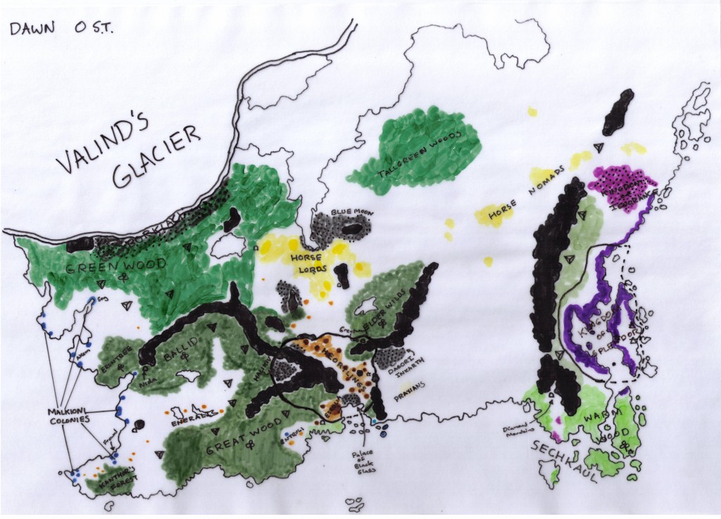
Each of the major cultures are colored coded: Purple for the Easterners, Brown for the Orlanthi, Yellow for the Solars, Blue for the Malkioni, Green for the Elves, and dark Grey for the Trolls. Plus symbols for Dragonewt cities, major Dwarf mines, and Hsunchen bands.
One thing this map illustrates is how predominant the Elder Races were at the Dawn, and how relatively insignificant the human civilizations were at the Dawn. Only the various Orlanthi settlements of Dragon Pass, the Kraloreli of the far east, the Horse Lords of central Peloria, and the small Malkioni settlements of the West are really worth mentioning. To put things in perspective, all those little brown settlements near Dragon Pass total less than 15,000 humans. Those little blue settlements in the far west totalled far less than that.
Only two political organizations are really worth mentioning at the Dawn: the Kingdom of Splendor (Kralorela) and the Shadowlands (also called the Unity Council).
The Kingdom of Splendor is ruled by glorious Emperor Yanoor who became Emperor at the Dawn (the Dawn occured once Emperor Vashanti departed for the Summer Land of Heaven).
The Shadowlands are the peoples who were united by Ezkankekko the Only Old Old to fight the Unity Battle that defeated Chaos and saved the world. The Unity Council joined human (Orlanthi), troll, elf, dragonewt, dwarf, and gold wheel dancer to save the world from destruction and revive the gods.
There’s lots of little details in the map itself, including many details that have never been published before in previous Glorantha books. And instead of just three maps like Trollpack had, we’ll have at least 9 historical maps (0 ST, 250 ST, 400 ST, 700 ST, 900 ST, 1100 ST, 1250 ST, 1450 ST, and 1550 ST).
Submitted by Andre Jarosch (not verified) on Wed, 01/06/2011 – 12:07.
I remember reading somewhere (obscure paragraph in an old booklet, Unfinished Work/Stafford Library book or in one of Gregs unpublished manuscript?) thhat there was a troll colony in the Seshnela/Ralios border area (later Guhan?) in early first age. If i remember correctly Arkat (in his time as soldier in the Brithini army, or as Seshnegi knight) helped clearing that region from trolls, so that by 430 or so no trolls were left in that area. When he came back to Ralios after his victory over Nysalor/Gbaji he established a new troll colony (Guhan) at the place where he originally helped to destroy one.
Do i remember so wrong?
Submitted by Jeff Richard on Mon, 30/05/2011 – 09:43.
Run it anyways! The Dragon’s Shudder was a great earthquake that destroyed many cities, killed hundreds of thousands, but did not appreciably change the coastline at this level of detail. The Suam Chow itself was created when Daruda the Dragon Emperor entered the world and cleansed it of the corrupt antigods. The cleansed area became a wide, shallow lake called the Suam Chow. (RM page 82-83).
Submitted by Scott on Mon, 30/05/2011 – 02:19.
Thanks Jeff. I very much appreciate those “extra” islands of lost Sechkaul, those “other” lakes of future Ralios and all those hsunchen markers. Strange that most of lost Slontos was apparently at one point aldryami country!I also like the revelation that despite “Kralorela is sinking” theories that have evolved over the years, the borders of the Dragon Empire have been relatively fixed (“cyclically perfect”) since time. Maybe the Suam Chow’s claimed a city or island now and then, but the rest was probably only the correction of False Dragon Ring “flawed cartography” and outright geomantic meddling.
Submitted by Iain Murray on Mon, 30/05/2011 – 02:04.
Ah, dang, and I had a whole campaign outline based in part on the geographical wreck of Kralorela at the end of the Second Age caused by the War in Heaven. Good job the players haven’t got there yet…I’m surprised, though, that this wasn’t caught in the revision of the Second Age book for MRQ2.
Submitted by Patrik Sandberg on Sun, 29/05/2011 – 22:41.Good! I never liked the look of Kralorela on the Mongoose Map and thought it wrong and incorrect.
Submitted by Jeff Richard on Sun, 29/05/2011 – 21:25.
I’m afraid Mongoose’s cartographer got it wrong. I’ve got all the maps Greg sent Mongoose and none of the detailed maps of the Second Age show the East looking that way (except a really crudely drawn “world map” that shows the huge amount of area under Middle Sea Empire dominance – which I fear their cartographer relied on). The answer is that Kralorela is largely unchanged since the Dawn (the Suam Chow was formed in the Storm Age, not in time). An earlier draft had the Suam Chow more filled, but Greg corrected it. There’s more islands in the Suam Chow since the Dawn, but the coastline is largely (but not exactly the same).
Submitted by Patrik Sandberg (not verified) on Sun, 29/05/2011 – 21:21.
I notice that Kralorela has exactly the same old jagged coastline as in the third age. On the Second Age maps from Mongoose it has far more land mass and a more “harmonious” coastline. (I presumed the Mongoose Glorantha map, at least, was based on Greg’s originals.) Which do you regard as the correct?