Skip to content
The Well of Daliath
Menu
Menu

The Size of Dragon Pass

Posted on October 29, 2009

29 October 2009

Those who are familiar with Greg Stafford’s Glorantha are likely familiar with the problem of scale in previously published maps. One map might say it is 50 miles from Clearwine Fort to Duck Point, another says it is only 30 miles. One map might display the continent of Genertela as being 3000 miles from west to east, but using the scale on another one gets the distance of only 1600 miles.

It is enough to drive a poor cartographer mad.

Fortunately, Colin Driver (our cartographer) is not a poor cartographer and was already mad to begin with. And so after much hard work he has resolved the scale of Glorantha issue once and for all. Genertela is approximately 3000 miles from west to east (which is comparable to the distance from the eastern seaboard of the United States to the western seaboard). It is approximately 50 miles from Clearwine Fort to Duck Point (as the Orlanthi holy man flies) and precisely 68 miles from Jonstown to AldaChur.

Here is a map of England superimposed over a map of Dragon Pass and the Holy Country to give a more local sense of scale:

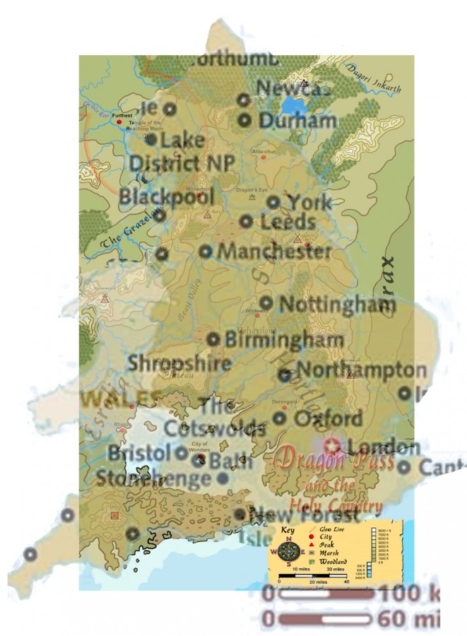
As you can see, the Kingdom of Sartar is roughly the distance from Nottingham to Durham and is comparable in size to the Anglo-Saxon Kingdom of Northumberia. In this comparison projection, Whitewall is approximately where Leicester would be, Duck Point near Manchester, Runegate outside of Leeds, and central Tarsh is in the Lake District. Boldhome would be somewhere near Hull. AldaChur would be somewhere in North Yorkshire.

Thus compared to England, the Kingdom of Sartar stretches from the Midlands to North East England. This is the canonical scale of Glorantha.

The Sartar book will contain many maps designed to give GMs and players a much better feel for the exact size of things in Dragon Pass, including:

  • A map of Dragon Pass and the Holy Country
  • A map of Sartar
  • A map showing the boundaries of all the tribes of Sartar
  • A map showing the major holy places of the Sartarites
  • A detailed map of the lands of the Colymar tribe
  • A map showing the boundaries of all the clans of Colymar tribe and their neighboring tribes.

And much more! Last I counted we had more than 20 maps in the Sartar Book.


Jeff Richard

Next
Previous
Map, Sartar – Kingdom of Heroes (preview), scale

Sections

  • Search Tips
  • Current RuneQuest Glorantha Publications
  • RuneQuest Glorantha Corrections and Q&A
  • Catalogue
  • References for Glorantha
    • Gloranthan Canon
  • Gloranthan Documents
  • RPG Systems & Versions
  • Gallery
  • About This Site
  • Get involved!

Latest Posts

  • The Nine Good Giant Mountains

    The Nine Good Giant Mountains are about 60 km or …
  • Why Most Sartarites Hate the Lunar Empire

    From time to time it is worth reminding people why …
  • Suntown and the Eiskolli

    Suntown has always been in the hands of the Sun …
  • A Few Notes on the Grantlands

    To the south of Sun County are the former Grantlands, …
  • Sartar Cities

    Sartar can be thought of a confederation of small cities …
  • Catalogue of the Gods revisited

    This piece from the Mythology book is among my absolute …
  • Thunderbolts in Art

    One of the things that really got me down the …
  • RuneQuest Art

    So let’s talk RQ art for a moment. For the …
  • Top Five RuneQuest Cults

    So it is absolutely no surprise to me that in …

Links

  • Chaosium
  • Chaosium’s RuneQuest RPG Wiki
  • Glorantha on BRP Central
  • RuneQuest on BRP Central
  • RuneQuest on Discord
  • Prince of Sartar Webcomic
  • Glorantha G+ Archives on Tapatalk
  • Search mailing list archive

Latest from BRP Central

  • Odayla Initiation Heroquest
  • Did anyone get a good look at WB&RM?
  • Clearwine Assembly Hill and Orlanth's High Holy Day
  • Sun County pdf is drivethrurpg’s Deal of the Day for July 1st
  • Permission to use exerpt from map in Starter Set in a Jonstown Compendium release?
  • Summon of Jaldon
  • Jonstown Compendium: Spawn of Molokka - The Cephalopods of Glorantha
  • Runelords and Retirement
  • Hospitality Hearth spirits - what are they ?
  • Clearwine Burned & Argrath's Orphan Childhood

Popular Tags

1625 ST Boldhome (large city) Chaosium Colymar (Sartar tribe) Contents Cult demographics Cults of Runequest (preview) Ernalda Esrolia (homeland) FRA Furthest (large city) G+ post Gods Wall Greg Stafford Guide to Glorantha (preview) Humakt Jar-eel Lunar Empire Lunar Pantheon Magazine Malkioni pantheon Map Michael O’Brien Mongoose MRQ1 New Pavis (small city) Old Glorantha Q&A Orlanth Orlanthi pantheon Photo reference Population demographics Prax (homeland) RQ3 RQG Sandy Petersen Sartar (homeland) Spirit Cult Star Subcult Tarsh (homeland & Lunar province) Troll Pantheon Yelm Yelmalio Yelm Pantheon Youtube

Recently added or updated

  • CHA4037 Dragon Pass – Q&A

  • CHA4034 Red Book of Magic – Chapter 02 Rune Magic Spells Q&A (A-M)

  • CHA4043 The Lightbringers – Q&A

  • CHA4029 RuneQuest Gamemaster Screen Pack – Q&A

  • CHA4036 RuneQuest Weapons and Equipment Q&A

  • The Garden, Big Rubble II

  • The Garden, Big Rubble I

  • Half-folk

  • Orlanth Rex and Sartar’s Lineage

  • The Triceratops Queen

  • 1557-1600 Conflict with the Lunar Empire

  • Why Most Sartarites Hate the Lunar Empire

  • The Nine Good Giant Mountains

  • Trolls of The Big Rubble

  • Dorastor (FRA-1993)

  • AH8592 Dorastor: Land of Doom (1993)

  • Rynglorem

  • Hobimarong

  • Sun County Continued part 1

  • Suntown and the Eiskolli

©2025 The Well of Daliath | Design: Newspaperly WordPress Theme