For those of you who wanted the references for Cory’s Prax landscape picture, here it is!
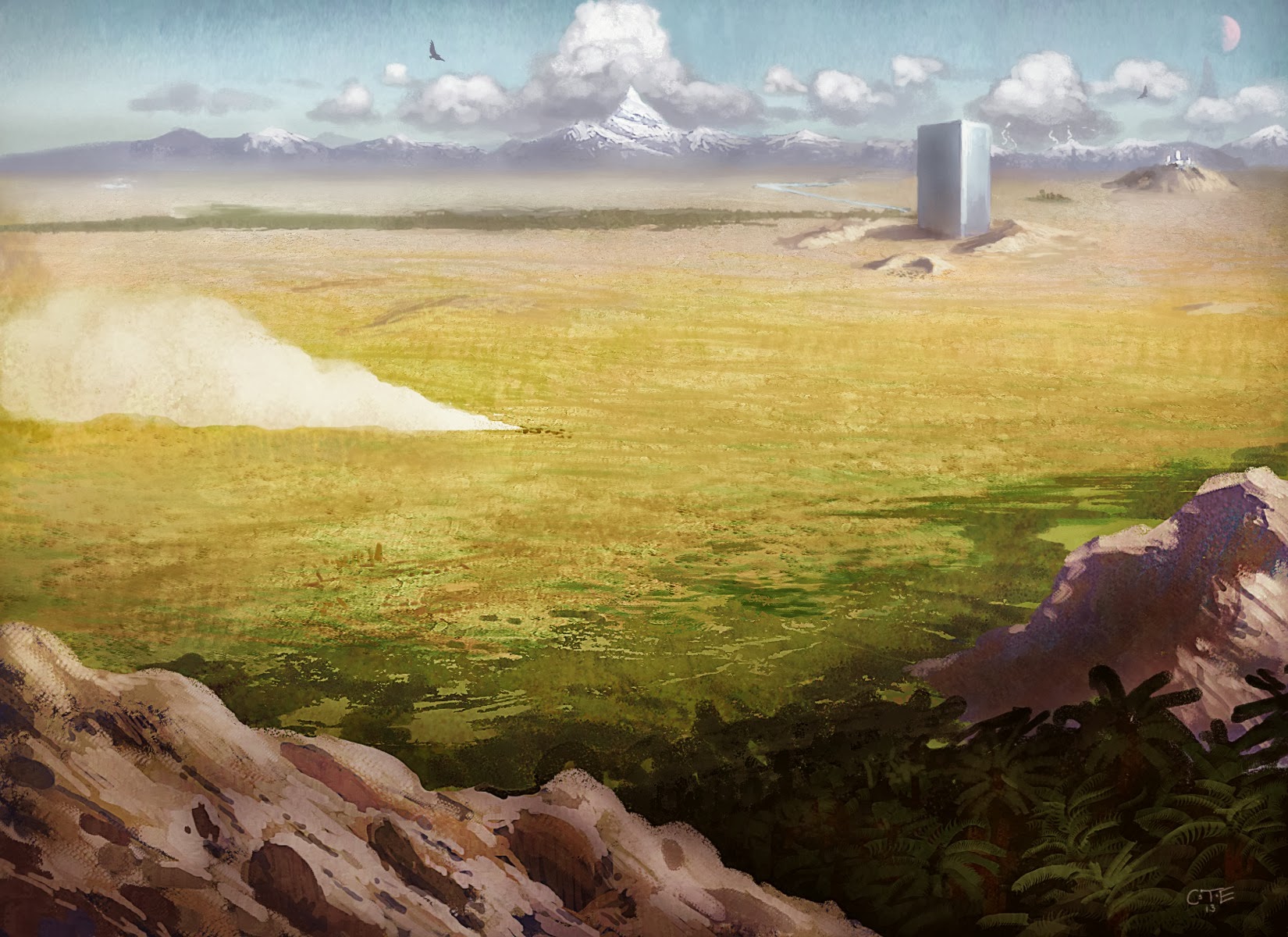
The viewer stands in the foothills of the Eiritha Mountains, overlooking the oasis of the Paps, a fertile spot in the desert (which leads to a huge underground temple complex). The elevation of the view point is about 2200 feet, and probably 500 feet or so above the oasis (imagine if the viewer is standing at the top of the cliffs in this picture looking at you: http://commons.wikimedia.org/wiki/File:Ein_Gedi_-_Lelik.jpg).
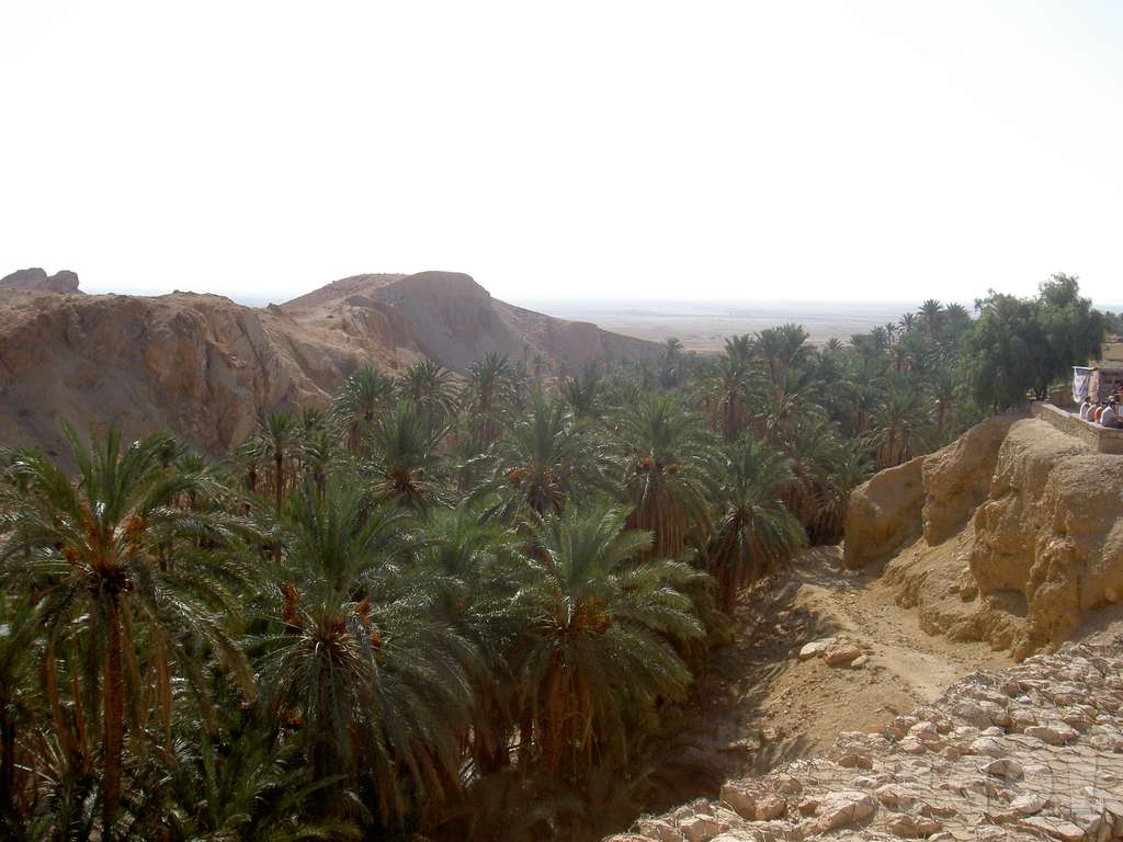
The Paps Oasis: The oasis is green and fertile, with palm trees and grass. Like this http://berdzik.eu/photo/2005/Tunisia/Mountain_Oasis.jpg, spreading out to this http://www.flickr.com/photos/incarnate/7915621972/ (but without the hills).
Prax: Beyond (say three hexes away) is Prax, a chaparral and sagebrush desert, like much of Nevada (which is a good comparison, as the Sierra Nevada range is analogous to the Storm Mountains).
http://en.wikipedia.org/wiki/File:Basin_and_Range_Nevada.JPG
http://commons.wikimedia.org/wiki/File:1st_Place_-_Spring_Storm_in_the_Great_Basin_(7186595011).jpg
http://en.wikipedia.org/wiki/File:Rachel_NV_Hwy375.jpg
http://en.wikipedia.org/wiki/File:WahWah.JPG
http://commons.wikimedia.org/wiki/File:Pyramid_Peak_from_Ash_Meadows_1.jpg
http://commons.wikimedia.org/wiki/File:DeepCreeksSnow.JPG
Deeper in Prax, a dust storm is being whipped up by a herd of animals somewhere along Caravan Alley (as on http://rpggeek.com/image/800392/pavis). The animals are too small to be identified, but the dust storm is visible.
.jpg)
The Block: An enormous block of magical rock, one mile high and a half-mile on each side, rises from hills of dirt. You can make it out on the Pavis cover (http://rpggeek.com/image/800392/pavis), but in this picture it is significantly closer (still maybe 50 miles away, but in the Pavis cover it is a good 110 miles away). The block is blue-grey in color (it is a metallic stone) and clearly unnatural. It should have the same disturbing effect of seeing Devil’s Tower in Wyoming (see http://2.bp.blogspot.com/_QrVhdHX1wz8/Sle2DTErslI/AAAAAAAAApg/ke2j6d5TmKM/s400/04DevilsTower.jpg, http://www.delfour.net/gdelfour/Photos/Devils_Tower/Photos/02%20Devils%20Tower.jpg
http://4.bp.blogspot.com/-l8CusJRvsLM/UAFB-GE1xKI/AAAAAAAAAZY/p9MeISGu5lQ/s1600/Devils+Tower+05.jpg), although the Block is MUCH bigger (Devil’s Tower rises about 1300 above the surrounding terrain and about 400 feet wide at the summit; the Block rises over 5200 feet above the surrounding plains and is about 2500 feet wide at the summit).
Stormwalk Mountain: Beyond the Block (about 55 miles) are the white capped Storm Mountains (think the Sierra Nevada range seen from Nevada http://www.pitt.edu/~cejones/GeoImages/3IntrusiveBodies/1Plutonsz/AlabamaHillsSierras.JPG or the Cascade Mountains viewed from the east http://www.houminn.com/storage/1%20Ellensburg%20and%20the%20Kittitas%20Valley.jpg?__SQUARESPACE_CACHEVERSION=1278055022847). They rise about 5000 to 8500 feet, with one mountain much bigger than the others – StormWalk Mountain.
Stormwalk Mountain rises over 10,000 feet and its top is covered in white ice year-round. It is in the shape of a cork-screw and has a discernable spiral pathway rising around its sides, seven times around to reach the ice-covered top. It once was a mountain god, but the mighty Storm Bull fought with it and twisted its right right off.
Tourney Altar (in front of the block) is a natural stone amphitheatre (like thishttp://en.wikipedia.org/wiki/File:Upheaval_Syncline_campsite.jpg or http://www.flickr.com/photos/piedmont_fossil/7681514040/).
Related Pages
- Coming Storm News
- Dara Happan Godswall (2013)
- Finishing with the East Isles section
- Full Map of Glorantha
- Genertela complete, Oceans ahoy!
- Getting closer!
- Getting very close with the East Isles!
- Guide status report
- Guide Status report
- Guide to Glorantha nominated for four ENnies 2015
- Guide to Glorantha Status report
- Guide to Glorantha wins Silver ENnie for Best Cartography
- Guide Update: To the South!
- Hrestol and the Vadeli Judges
- Hsunchen (Rathori and Uncoling) by Jeff Laubenstein
- Inspiration for the Gods Wall II
- Kingdom of War
- Layout from the Guide
- Layout on the Guide has official commenced!
- Map of Nochet 1621 ST (2013)
- Moon Design wins 2015 Diana Jones Award for Guide to Glorantha!
- New East Isles info
- Ouranekki PDF available (2013)
- PDF downloads of the Guide and Atlas for Kickstarter backers
- Penultimate Guide Preview
- Pre-Order the Guide and Argan Argar Atlas now!
- Pre-ordering the Guide to Glorantha and the Atlas – a few days left!
- Preorder the Guide to Glorantha NOW!
- Preview of Vol. One for Kickstarter backers
- Reconstructing Slontos – 2nd Age
- Reconstructing Slontos – 3rd Age
- Reconstructing the Hero Wars
- Sample cultural distribution maps
- Showing off the Guide to Glorantha
- Sixth Wane Ouranekki board (2013)
- The Gloranthan Seasons by Jennifer Lange
- The Gods Wall
- The Guide has left the Building
- The Guide is at the Printers!
- The Guide is being bound as we speak!
- The making of a Hon-eel picture
- The Mostali certainly aren’t generic fantasy… (2013)
- The Ultimate Preview and the Kickstarter Survey
- Ultimate Previews and Surveys go out tomorrow!
- Unveiling the Guide to Glorantha
- Update on the Guide – Delays and Headaches
- View of sacred Prax from the Paps (2013)
- Volume 2 and the destruction of Imperial Seshnela
- Vormain Map Creation – Step 1
- Vormain Map Creation – Step 2
- Waertagi dragon ship by Jeff Laubenstein (2013)
Page Last updated: 2022-12-27 12:10:31