Skip to content
The Well of Daliath
Menu
Menu

Greater Lunar Empire

Posted on September 6, 2013

Submitted by Jeff on Sun, 09/10/2011 – 12:42

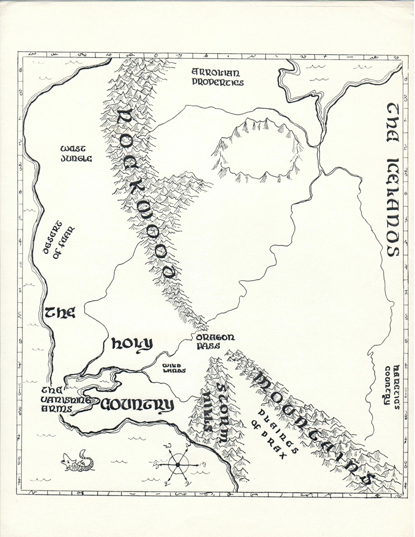
Searching through the archives of the Jonstown Library, I came upon this gem of a map. The sages told me that it was a copy of a map on prepared by the Imperial Surveyors in Furthest. I told them that there were no jungles in Seshnela. The chief librarian scoffed at me, informing me that clearly the Lunars, as masters of the known world, had a better idea what lay at the outskirts of their empire than a mere adventurer.

Greg’s Original Map
Original overlay for the map

Submitted by Howard (not verified) on Wed, 07/12/2011 – 01:40.
Actually, after some consideration, I can see how a Lunar cartographer would want to downplay anything to do with Orlanth!


Submitted by Howard (not verified) on Tue, 06/12/2011 – 18:19.
Kero Fin is missing, which I find odd. I am digging the distortion and things like “Desert of Fear” – which I think is a product of the map maker’s imagination – meaning “game”, as well as “RW”, obviously! 🙂


Submitted by Peter Metcalfe (not verified) on Mon, 10/10/2011 – 13:59.
I think the Desert of Fear is more likely to be Arolanit.


Submitted by Phersu (not verified) on Sun, 09/10/2011 – 21:24.
The Holy Country used to be huge before Belintar was slain! No wonder it took so long to invade Kethaela. I wonder what happened to that “desert of fear”. It must be Slontos.


Submitted by Charles Corrigan (not verified) on Sun, 09/10/2011 – 20:52.
LOL – Caution: archaeology in progress here!


Submitted by Jeff Richard (not verified) on Sun, 09/10/2011 – 18:55.
Actually Colin, I think Peter is (correctly) referring to an even older map of Prax than the one you have seen. This one was done on hexpaper back in the mid-70s.


Submitted by Colin Driver (not verified) on Sun, 09/10/2011 – 17:47.
Nice theory Peter but Greg’s original Prax map specifically mentions Corflu with the following: “(Note – Corflu is on a dry (non-marsh) island).” The only bit of correction fluid on the map is in the Eiritha Hills south of Agape.
Loving the Lunar map though. It’s always cool to see cartography from an inhabitants’ sewed perspective.


Submitted by Peter Metcalfe (not verified) on Sun, 09/10/2011 – 15:09.
You could also post the old map from Nomad Gods which has Christian’s Bay in it. I have a feeling Corflu got its name because Greg wanted to ink it over with correction fluid but couldn’t find it handy so wrote Corflu! with an arrow pointing to the Bay. William Church misunderstood the legend and so placed the town of Corflu on the bay.


Submitted by Keith (not verified) on Sun, 09/10/2011 – 13:55.
It is clearly done by way of some sort of projection – as if it were a map of a globe, or perhaps viewed from a globe like the moon. i.e the dimensions are distorted.

Jeff Richard

Next
Previous
Lunar Empire, Maps, Moon Design Blog, White Bear / Red Moon

Sections

  • Search Tips
  • Current RuneQuest Glorantha Publications
  • RuneQuest Glorantha Corrections and Q&A
  • Catalogue
  • References for Glorantha
    • Gloranthan Canon
  • Gloranthan Documents
  • RPG Systems & Versions
  • Gallery
  • About This Site
  • Get involved!

Latest Posts

  • The Nine Good Giant Mountains

    The Nine Good Giant Mountains are about 60 km or …
  • Why Most Sartarites Hate the Lunar Empire

    From time to time it is worth reminding people why …
  • Suntown and the Eiskolli

    Suntown has always been in the hands of the Sun …
  • A Few Notes on the Grantlands

    To the south of Sun County are the former Grantlands, …
  • Sartar Cities

    Sartar can be thought of a confederation of small cities …
  • Catalogue of the Gods revisited

    This piece from the Mythology book is among my absolute …
  • Thunderbolts in Art

    One of the things that really got me down the …
  • RuneQuest Art

    So let’s talk RQ art for a moment. For the …
  • Top Five RuneQuest Cults

    So it is absolutely no surprise to me that in …

Links

  • Chaosium
  • Chaosium’s RuneQuest RPG Wiki
  • Glorantha on BRP Central
  • RuneQuest on BRP Central
  • RuneQuest on Discord
  • Prince of Sartar Webcomic
  • Glorantha G+ Archives on Tapatalk
  • Search mailing list archive

Latest from BRP Central

  • Odayla Initiation Heroquest
  • Did anyone get a good look at WB&RM?
  • Clearwine Assembly Hill and Orlanth's High Holy Day
  • Sun County pdf is drivethrurpg’s Deal of the Day for July 1st
  • Permission to use exerpt from map in Starter Set in a Jonstown Compendium release?
  • Unsung Areas of the Big Rubble and Prax?
  • Sun County T-Shirt
  • Summon of Jaldon
  • Jonstown Compendium: Spawn of Molokka - The Cephalopods of Glorantha
  • Runelords and Retirement

Popular Tags

1625 ST Boldhome (large city) Chaosium Colymar (Sartar tribe) Contents Cult demographics Cults of Runequest (preview) Ernalda Esrolia (homeland) FRA Furthest (large city) G+ post Gods Wall Greg Stafford Guide to Glorantha (preview) Humakt Jar-eel Lunar Empire Lunar Pantheon Magazine Malkioni pantheon Map Michael O’Brien Mongoose MRQ1 New Pavis (small city) Old Glorantha Q&A Orlanth Orlanthi pantheon Photo reference Population demographics Prax (homeland) RQ3 RQG Sandy Petersen Sartar (homeland) Spirit Cult Star Subcult Tarsh (homeland & Lunar province) Troll Pantheon Yelm Yelmalio Yelm Pantheon Youtube

Recently added or updated

  • Wyrm’s Footnotes #08 (1980)

  • Manthi

  • Magasta

  • Tales of The Reaching Moon #10 (GBR 1993)

  • Tales of The Reaching Moon #09 (GBR 1993)

  • Tales of The Reaching Moon #08 (GBR 1992)

  • Notes on The Holy Country III

  • Jadarenasa

  • Boldhome Booklet

  • Sea Eagle

  • Loon

  • Otter

  • Turtle

  • The Culbrea Tribe II

  • The Forty-eight Old Ones

  • Father of Independents

  • Vasana’s Tattoos WiP

  • Keraun

  • Pamalt

  • The Tales of the Reaching Moon – Index

©2025 The Well of Daliath | Design: Newspaperly WordPress Theme