Home › Forums › Glorantha › Glorantha Discussions › Sartar, a cultural crossroads not a backwater
- This topic has 33 replies, 10 voices, and was last updated 6 years, 9 months ago by
 Graeme Vallance.
-
AuthorPosts
-
September 3, 2013 at 9:53 am #5165
 Jeff RichardKeymaster
This comes out of a discussion of the size of Sartar on the G+ community, but I thought it worth posting up here.
I think that the period of 1602-1625 does tend to give a misleading impression of Sartar. From 1492 to 1601, Sartar was a wealthy and regionally important principality not quite allied with the Holy Country, but certain quite friendly. Sartar sat right on the main trade route between the Lunar Empire and the Holy Country, and with its road system, it really was the cultural crossroads. The House of Sartar kept the many tribes (or cantons, if you want to think Swiss) in line, arbitrating disputes, and creating win-win situations for all involved. The House of Sartar was regionally important enough to be the King of Dragon Pass for 41 out the 62 years there has been a High King since 1492. Sartar was NOT a backwater.
Wealthy Sartarites (chiefs, nobles, thanes, merchants, temples, etc) had access to luxury goods from the Holy Country and the Lunar Empire. Wall paintings and amphorae would likely look a lot like what you might see in Heortland, Esrolia, or the Lunar Provinces. A well-armored thane in Sartar might have armor remarkably similar to a Lunar officer from the Provinces.
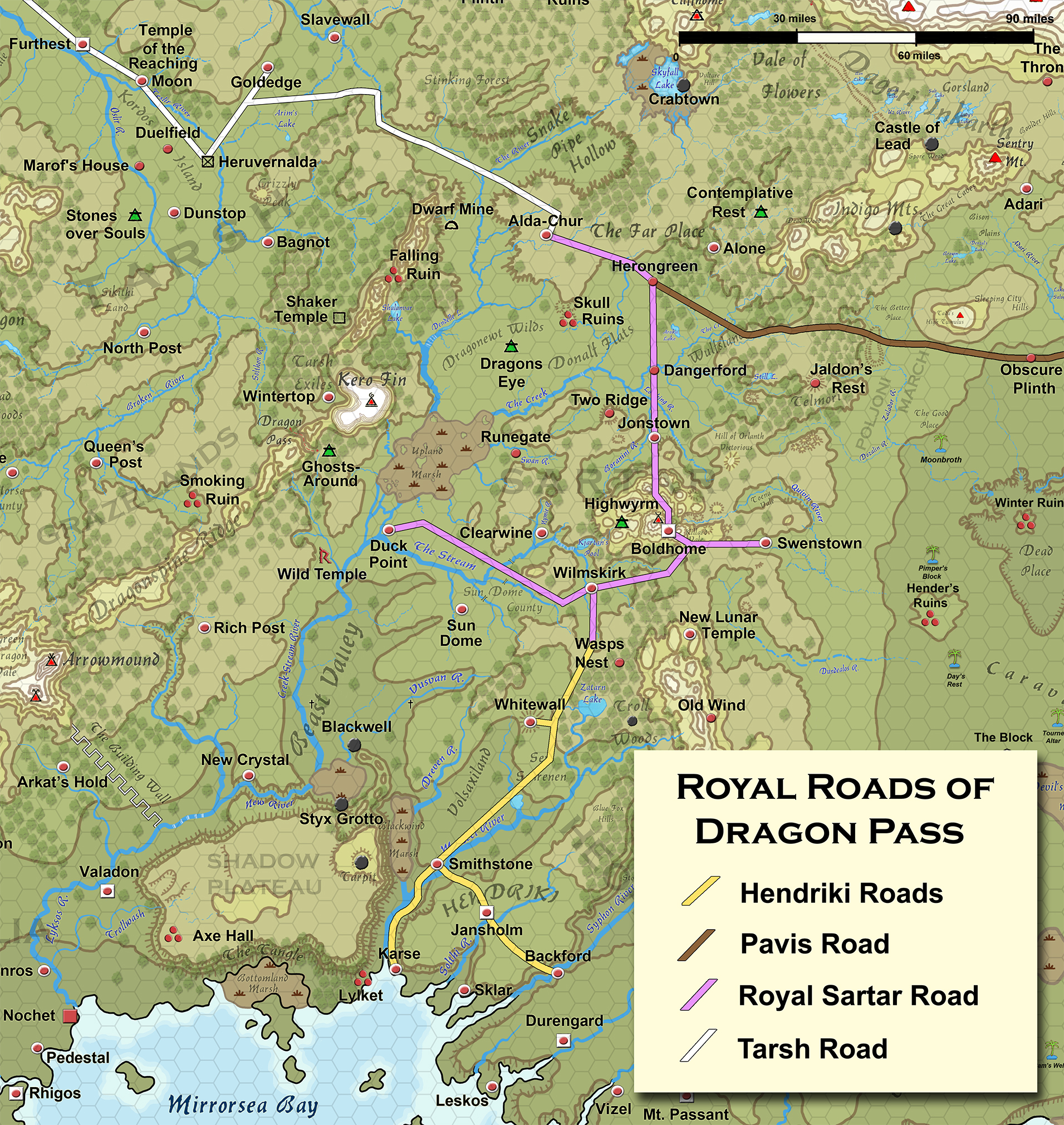
It is worth looking at the main events in Sartar in the decade after the Dragonrise. After 1625, Sartar quickly becomes liberated, regains the Far Place in 1627, and Argrath became the leader of an alliance that included Heortland, Esrolia, and Prax by 1628. Argrath became King of Dragon Pass by 1629. Tarsh itself was conquered between 1631 and 1634. Here’s that Royal Roads map that helps show how the main roads ran right through Sartar:
 September 3, 2013 at 10:22 am #5516
 David ScottKeymaster
What about feeder routes that don’t show on this map? Such as the caravan routes from Swenstown in and out of Prax. There must be a route down to Nochet as well, not as important, but certainly feeding out from the area.
September 3, 2013 at 10:28 am #5517Jeff RichardKeymasterThat’s not a royal road, of course. The Trade Route map (yes, there is one in the Guide), shows that caravan routes go from Nochet to Duck Point, then either over the royal road or over Dragon Pass through the Grazelands. But the Royal Road is likely far far easier.
September 3, 2013 at 10:32 am #5518 Joerg BaumgartnerSpectator
The same cosmopolitan influence can be said about the Grazelands. The roads may be worse, but for Esrolian traders, the riverine leg to New Crystal or even further upriver might be an alternative to the well-established road network of Esrolia (missing on your map). As far as overseas goods are concerned, Sartar gets the trade from Karse while the trade from Nochet is more likely to go through the Grazelands.
I would like to stress that Sartarite cities and tribal seats on the major roads may well be somewhat cosmopolitan (in as far as Orlanthi can be said to be cosmopolitan), but the rural backwaters are just that. A cottar’s home won’t really reflect much of the crossroads effect, though probably slightly more than his vendref cousin’s home in the Grazelands.
September 3, 2013 at 10:37 am #5519Jeff RichardKeymasterActually not. Most trade from Nochet going into the Lunar Empire either goes upriver to Duck Point and is then carried over the royal roads, or is transshipped to Karse and then carried over the royal roads. I’d estimate that about 85% of that traffic goes through Sartar, not the Grazelands. But even with only 15% of that trade, the various Trade Posts of the Grazelands are going to be pretty prosperous market towns.
As for whether a poor peasant is going to be exposed to cosmopolitan luxury goods like a wealthy noble or temple – of course not. But that’s true in the Lunar Heartlands as much as in Sartar.
September 3, 2013 at 10:51 am #5520David ScottKeymasterSo the rivers play a major role as feeder routes.
September 3, 2013 at 10:56 am #5522Jeff RichardKeymasterAbsolutely. It easiest to carry goods over navigable waters. Unfortunately, the Upland Swamp is navigable only by the little duck boats, and there’s a huge system of cascades upriver of the Marshes in any case. So goods get loaded/unloaded at Duck Point. From there, the easiest network is to take the Sartar Royal Roads to Wilmskirk, Boldhome, Jonstown, and then Alda-Chur. From there, you take the Tarsh Road to Furthest and load your goods onto boats going down the Oslir.
September 3, 2013 at 11:22 am #5523David ScottKeymasterWhat about the Oslir River, that goes straight into the heart of the Empire. Furthest would appear to be a sensible staging post for river transport.
September 3, 2013 at 11:31 am #5524Jeff RichardKeymasterYep, that was exactly my point. Goods going to or coming from the Lunar Empire get loaded to or offloaded from boats at Furthest. The Tarsh Road/Sartar Royal Road is the main overland route for goods going between the Lunar Empire and the Holy Country. And since nearly ALL goods going to/from the Lunar Empire from/to Ralios, Seshnela, Fronela, Teshnos, the East Islands, and Pamaltela goes through Nochet, you get an idea how important that route is.
September 3, 2013 at 11:57 am #5525Jeff RichardKeymasterOf course, the main problem with the river route between Nochet and Duck Point is the ten miles of cascades upriver from the Building Wall, which likely requires portage to New Crystal City. I suspect that the easiest route is actually Nochet to Karse, the on the Hendriki Road to Roadsend, and then the Sartar Royal Road/Tarsh Road to Furthest. That’s maybe 50% of the traffic. 35% probably take the River route to Duck Point and then the Sartar Royal Road/Tarsh Road to furthest. The last 15% take the River route to Duck Point, and then go over Dragon Pass through the Grazelands to Tarsh. Those percentages no doubt change based on local politics. If the Grazelanders are particularly friendly or Sartar is in rebellion, perhaps they get 35% of the traffic. If Volsaxiland is in turmoil, then maybe the River route gets 75% of the traffic. If there is a Duck Hunt, then the River route percentage declines. And so on.
September 3, 2013 at 11:58 am #5526David ScottKeymasterHow extensive is the Tarsh Road, where does it go after Furthest.
September 3, 2013 at 12:00 pm #5527Jeff RichardKeymasterWithout looking at the maps, I am pretty sure it goes to Talfort and then on to Filichet. From Filichet you have the Daughter’s Road to Mirin’s Cross and then on to Jillaro and the Lunar Heartlands.
September 3, 2013 at 12:05 pm #5528 CharlesKeymaster
The Royal Road network of Sartar was not just an engineering feat, if I remember correctly. There was much magic involved in maintaining the roads and protecting travelers from bandits etc.
Speculating, I imagine that when the Lunars wiped out the House of Sartar, they did not realise how tied up the House was in maintaining the magic of the roads. So they would have been pretty displeased at how quickly the quality and speed of travel fell off as these roads are their main route to the richest city in the world.September 3, 2013 at 12:30 pm #5529 Alberto Martín de Hijas ListeSpectator
What about Prax? You have river transport from Corflu to Pavis and, afterwards, a secure land route to the Oslir. It couldn’t take most of the traffic but it is a good alternative (specially in the 1612-1619 period).
September 3, 2013 at 12:35 pm #5530Jeff RichardKeymasterCorflu is a miserable failure of a port city. Nochet is the largest, richest trade center in the world. That’s where the action is.
-
AuthorPosts
- The forum ‘Glorantha Discussions’ is closed to new topics and replies.