Home › Forums › Glorantha › Glorantha Discussions › The Big Rubble at world scale
- This topic has 8 replies, 6 voices, and was last updated 4 years, 10 months ago by
 Styopa.
-
AuthorPosts
-
January 19, 2015 at 5:16 am #13681
 Roko JokoSpectator
The Big Rubble encloses a bigass area, more than a full 5-mile Gloranthan hex. So I thought it would be interesting to take the latest Big Rubble map (glorantha.com/docs/map-of-the-big-rubble), trace the major areas, and superimpose it onto the hex map in the GtG/AAA. Here is the result:
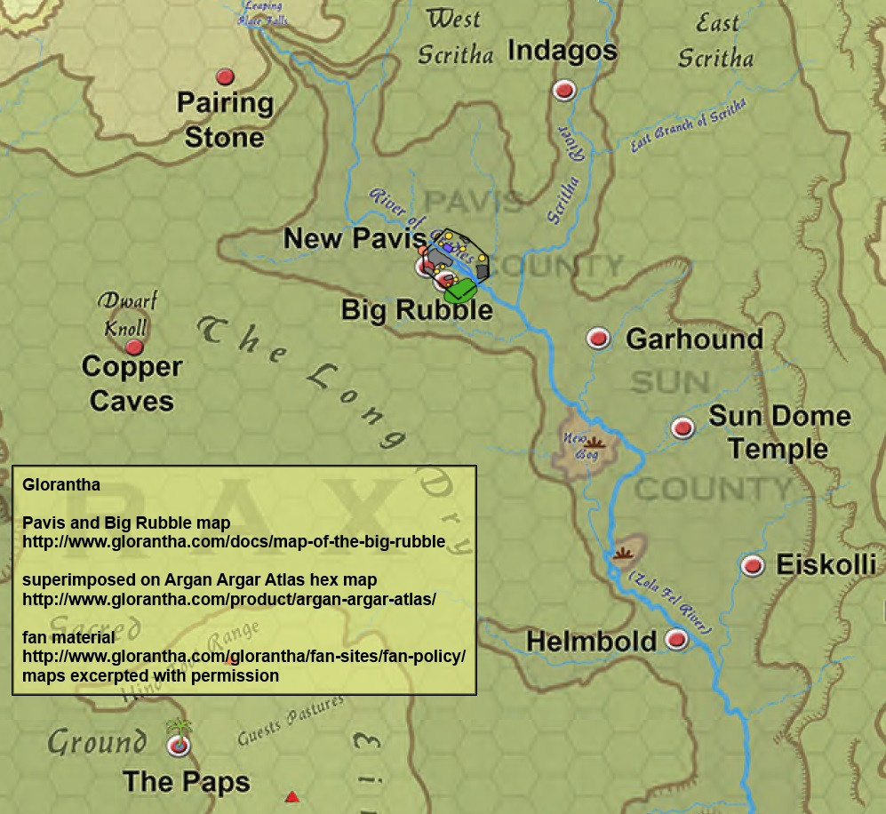
Two small comments. One is that the two maps disagree about the compass orientation of the river, so to make it fit the AAA map better I rotated the Big Rubble map about ten degrees counterclockwise. Another is that according to the AAA map, the Zola Fel tributary to the east of the Rubble, called Stormwater Creek on some maps, must be pretty close to the city walls. Likewise the other creek, on the opposite side of the river, is not that far away either.
January 19, 2015 at 5:20 am #13682Roko JokoSpectatorJanuary 19, 2015 at 9:14 am #13684Roko JokoSpectatorThe text of Pavis: Gateway to Adventure says the Rubble is 10 square miles, but that’s very inconsistent with the map, also in that book. The map shows a tilted rectangle of about 6×8 miles, with corners cut, so as to enclose somewhere around 42.5 square miles. That’s actually just about the area of 2 hexes, which are 21.65 square miles each.
January 19, 2015 at 10:00 am #13685 Christian Jensen RomerSpectator
Which is correct? If the map dimensions are then the hills that utterly dominated me 3D model of the Rubble making it look nothing like the illustrations might finally be less prominent.
Or maybe the summit heights on old maps given are above sea level?
January 19, 2015 at 11:54 am #13688 Joerg BaumgartnerSpectator
It would be in keeping with the Elder Wilds map to give absolute height above sea shore level.
Whether that is “above sea level” is another question – Gloranthan bodies of water can define their surface level if they are sufficiently alive. Even after spawning Worcha (yielding all of their active energy to the attempt to crush Kerofinela) the two standing waves across the Rockwoods still remained in place, forming a huge standing wave only pierced by some mountain tops or tree tops.
A ship crossing the Homeward Ocean might have to row “up” the doom currents, which at their most peaceful may appear like Sahara sand dunes made of water.
These degrees of being alive also continue underground, within the soil. Cam’s Well isn’t fertile because there is an aquifer, but there is an aquifer rising above the surrounding level of underground water because it is animated by Cam.
January 20, 2015 at 2:31 pm #13840 David DunhamSpectator
For reference: An 8 km hex has an area of 55.43 km^2.
Disney World is about two hexes (see http://www.wolframalpha.com/input/?i=55.43+km%5E2).
May 18, 2015 at 11:43 pm #15970Roko JokoSpectatorI double-checked these measurements against the size of New Pavis. They come from the Big Rubble map on p. 274 of P:GtA. That map shows the area of New Pavis outside the Big Rubble walls at around 1200 meters tall by 1500 meters wide, using the orientation where the river is straight up-and-down.
.
However, the map of New Pavis on p. 215-216 of the same book shows those dimensions at one third that size, 400 x 500 meters. Looking at the sizes of the buildings and streets, I want to say that size probably works better for New Pavis than 1200 x 1500 meters. It’s also roughly consistent with the text on p. 145: “about 1700 feet on a side”.
.
If you set the Big Rubble map on p. 274 to that scale, the legend should show the scale in feet rather than yards. Then the area inside the Big Rubble walls totals about 4.25 square miles. Unfortunately that’s not much more consistent with the text, which says on p. 145 and 272 that it’s 10 square miles. In any case, 4.25 square miles and 10 square miles both fit well within one hex.July 3, 2015 at 6:40 pm #16512 Simon PhippSpectator
Scales have always been an issue with the older Gloranthan maps.
If you take New Pavis and the Big Rubble as it has been written, then it is pretty small, at least to modern eyes.
August 12, 2015 at 8:38 pm #16958StyopaSpectatorThen again, isn’t pretty nearly every medieval/ancient city pretty tiny by modern standards?
Nineveh was ~100k people in what, about 6 sq km?
That’s 16000 people per sq km, NYC is only about 10k. That density would be comparable to modern Cairo.The fact is, when you have to walk everywhere and carry things by hand, people pack a lot closer.
-
AuthorPosts
- The forum ‘Glorantha Discussions’ is closed to new topics and replies.